


Annerley Junction
Gallery
URPoint Details
Annerley, an inner residential suburb, is five km south of central Brisbane. It is thought that it was named after the town of Annerley in Surrey, England.
The suburb extends southwards from Dutton Park (Cornwall Street) to an irregular boundary running east of Yeronga Park. It is bordered on the west by the railway line to the Gold Coast and is intersected by Annerley (formerly Boggo) Road and Ipswich Road.
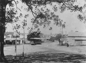
In 1866 a hotel, the Junction was licensed at the corner of Boggo and Ipswich Roads, marking the beginning of Annerley Junction around which a shopping centre grew. During the 1880s the township took shape as closer-settlement increasingly displaced dairying. Urbanisation increased with the opening of the Boggo post receiving office (1880), establishment of the railway (1884), opening of a Methodist church (1885), rebuilding of the Junction Hotel and the opening of a provisional school (1888). The school was attended mainly by children from families on the recently subdivided Thompson Estate, immediately north-east of Annerley Junction.
A short way north a railway station was built at Dutton Park (1891) and on the western edge the Fairfield station was opened in 1896. It was the
- Type:
- Landmark