


Archerfield Airport history: location Claimed
Gallery
URPoint Details
From around 1826, two years after Brisbane was first settled, the current Archerfield Airport area would have been part of Cowper's Plains (now Coopers Plains). Dr Henry Cowper was the first medical officer in the settlement of Brisbane.
Dr Cowper would often travel to Limestone Hill (now Ipswich) and camp half way at a Government cattle camp in the general area which became known as Cowper's Plains.
The land upon which Archerfield Airport is now situated (Portion 18, Parish of Yeerongpilly) was originally purchased in 1855 by Thomas Grenier, publican of the Brisbane Hotel in Russell St, South Brisbane. He purchased 640 acres of lightly timbered alluvial soil, some of the best grazing land in the district, for a price of £1,920.
The first freehold land in the area was sold as Country Lots in the 1850s with more being sold through the 1860s and 1870s. Some of the families who bought these early lots and lived in the Archerfield area were:
- Boyland
- Freney
- Grenier
- Grimes
- Moody
- Mortimer
- Whitfield
Thomas Grenier called his property ‘Oomoropilly’. By April 1862 the property was almost established with most of the fences in place, plus a cottage with outbuildings and a stable erected.
By 1865 the property had been subdivided into three farms. Thomas’s son George Alexander Grenier and his wife Sarah Greenwood lived on the middle farm where they had been since 1863. They lived in the homestead called ‘Willows’ which fronted onto Mortimer Road.
Franklin Grenier occupied the farm which fronted onto Mortimer and Beatty Roads, and William Leichhardt Grenier ran the farm called ‘Stoneleigh’ which had a long frontage onto Oxley Creek.
Thomas Grenier died in 1877 and was buried at the cemetery on his property. It was known as Oxley Cemetery at that time. This is now known as ‘God’s Little Acre’ and it is today located at the main entrance to Archerfield Airport.
Franklin Grenier died in 1889 and his farm was bought by the Beatty family in the early 1890s. The other two farms were also sold in the early 1900s.
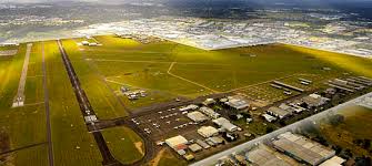
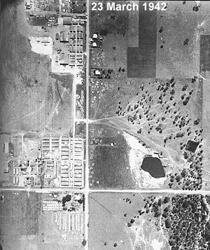
In 1927, Captain Lester Brain, chief flying instructor for Qantas Airways, landed his de Havilland DH-61 on Franklin’s Farm which was located at the western side of the present airport. His mission was to see if the site was suitable to become an airfield.
- Type:
- History
Map Location
Price List
-
 $0.00
$0.00