


")
Gallery
URPoint Details
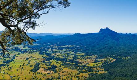
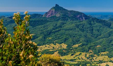
Wollumbin (Mount Warning)
Wollumbin (Mount Warning) summit track is a sacred place to the Bundjalung People, and was declared an Aboriginal Place in 2015. Visitors are asked to respect the wishes of the Bundjalung Elders and avoid climbing this very difficult track.
Wollumbin, which means ‘cloud catcher’ to some Aboriginal People, is a traditional place of cultural law, initiation and spiritual education for the people of the Bundjalung Nation. Under Bundjalung law, only certain people can climb the summit. Out of respect for their law and culture, consider not climbing the summit.
If you choose to tackle this challenging track, take extreme care. The 8.8km return walk takes at least 5hrs and is long and steep, with a very strenuous 100m vertical rock scramble to reach the summit. The high, exposed summit can attract wild weather and the track shouldn’t be attempted in poor conditions, especially during thunderstorms. In winter, it’s important to start before midday to avoid a dangerous descent in the dark.
You may prefer the park’s kid-friendly Lyrebird track, which winds through Gondwana rainforest to a lookout. Some of the best views of Wollumbin can be found along Pinnacle walk and lookout in Border Ranges National Park. You can also try Goorgana walking track or Pholis Gap walking track in nearby Nightcap National Park, or Best of All lookout at Queensland’s Springbrook National Park.
Geologists believe Mt Warning last erupted 23 million years ago and was active for three million years. It is a volcanic plug that formed alongside the major volcano if the region, the Tweed volcano, that formed the caldera region now known as the Scenic Rim.
Official height 1156metres (3,793 ft). Summit elevation 1125m.
Source: NSW National Parks
Breathtaking scenery
The Scenic Rim region is named becasue it is rimmed by an imposing volcanic mountain range, dating back millions of years.
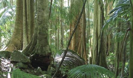
The legacy of this volcanic past is Australia’s most accessible World Heritage-listed rainforests and rich alluvial soil and remains the lifeblood of the region.
Tourism and agriculture are the Scenic Rim’s two leading industries.
The Scenic Rim is home to six National Parks and is a haven for bushwalkers, naturalists, birdwatchers and lovers of spectacular views.
The region is also a food bowl for Queensland and markets further afield. During winter the alluvial valleys produce vegetables for markets up and down the Australian east coast. The Scenic Rim is also home to beef, pork and poultry producers and boasts growing boutique and gourmet food, wine and craft beer industries.
Geo history
It’s not until you investigate how the Scenic Rim came to be that you realise how significant this dense cluster of mountains is. The Scenic Rim Mountains and the Mt Warning area in northern NSW are known as the Green Cauldron and were once a volcanic hotspot, which over the years has grown into a lush landscape featuring six National Parks.
Scenic Rim geologist, Dr John Jackson, says the Scenic Rim was formed over a three million year period, more than 26 million years ago.
“As the heat intensified, volcanic activity erupted and the mountains formed from magmas and lavas that intruded from the hotspot,” Dr Jackson explains.
Mt Warning and Focal Point Mountains are known volcanoes and John says there were most probably others, but proving it is difficult.
“Australia was travelling north over a hotspot, then it changed direction and slowed down and that is the real reason for the Scenic Rim. The change in direction and the slower speed allowed for the build up of the dense mountain range. To give you an idea of the speeds, when Peak Crossing to the Glass House Mountains was formed we were travelling about 70km/million years. That speed slowed to 26km/million years when the Scenic Rim was created and you get the effect of the mountains that are all stacked up together.
“By the time we reached Mt Warning, Australia speeds up again and the mountains are more dispersed.”
Source: Scenic Rim Regional Council.
- Type:
- Indigenous